Thinking about a new deck, a garage, or beach access on your Ogunquit property? Shoreland rules can feel confusing when all you want is a clean plan and a clear timeline. You are not alone. The good news is you can avoid most surprises if you start with the map and design to the standards that already apply. In this guide, you will learn how Ogunquit’s shoreland zones work, what typical setbacks look like, and which projects trigger permits so you can plan with confidence. Let’s dive in.
Start with the map
Before you sketch anything, confirm whether your lot falls within a shoreland zone and which district it is in. In Maine, the state sets minimum standards through the Shoreland Zoning program, and towns like Ogunquit adopt local ordinances and maps that can be more protective. Your parcel might also include layers like wetlands, floodplains, or dunes that add rules. Checking the map first keeps your design on track and saves time.
Who sets the rules
Maine’s Department of Environmental Protection (Maine DEP) runs the statewide Shoreland Zoning program and enforces state law. Ogunquit adopts and enforces its own shoreland ordinance and zoning map that must meet or exceed state minimums. Some projects also need permits from the U.S. Army Corps of Engineers, especially for tidal work like docks or seawalls. If your lot is in a FEMA coastal flood zone, elevation and floodplain rules apply too.
What shoreland zones mean
“Shoreland” usually includes land within set distances of the ocean, rivers, streams, certain ponds, and wetlands. On the map, you will see districts that signal what you can do and what you must avoid.
Typical district labels
- Resource Protection (RP): The most restrictive areas. These protect fragile resources like wetlands, steep slopes, or high value habitat. New structures are often limited or prohibited.
- Limited Residential (LR): Allows residential use with strict standards for setbacks, clearing, and lot coverage.
- General Development or Limited Commercial: Allows more intensive use in built-up areas, but shoreland performance standards still apply.
Setbacks and dimensional standards
Exact numbers come from Ogunquit’s ordinance, but you can expect common patterns across Maine.
Structure setbacks
- Principal structures are often set back 75 to 100 feet from the normal high-water line or the upland edge of a wetland. RP zones may require more distance or may not allow new buildings.
- Accessory structures sometimes have reduced setbacks if they stay under a size cap, but many towns require larger sheds or garages to meet the same setback as a house.
Lot coverage and impervious area
Many ordinances limit how much impervious surface you can add within the shoreland zone. Exceeding those thresholds may require mitigation such as added stormwater controls or replanting. Plan hardscape and roofs with runoff in mind from the start.
Vegetation buffers
Most shoreland rules protect a vegetated buffer along the water’s edge, often within the first 50 to 100 feet. Clear-cutting is usually prohibited in that area. Limited paths, pruning, or small view windows may be allowed, and replanting is commonly required after removal.
Nonconforming structures
If your home or cottage sits closer to the water than today’s setback, it is likely nonconforming. Repairs are usually fine, but expansions toward the water are tightly controlled. Enlarging beyond a set percentage of footprint or volume often needs a variance or special review.
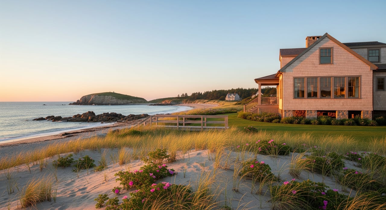
Coastal stabilization and access
New seawalls, bulkheads, or revetments face strict review and usually require local, state, and federal permits. Towns encourage softer options like dune restoration or beach nourishment where feasible. Stairs or paths across dunes and coastal sand areas require careful design and review.
Docks, piers, and ramps
Tidal structures usually require Maine DEP and Army Corps permits, plus local approval. Freshwater docks may be regulated locally and by the state depending on the waterbody.
Septic and wells
Septic repairs or new systems near the shoreline often trigger plumbing and state review. Setbacks from water and wetlands are controlled, and capacity increases can require additional approvals.
Common projects and permit triggers in Ogunquit
Every ordinance is different, so confirm details with the Town of Ogunquit Code Enforcement Office. Here are typical triggers.
Additions or rebuilding
- New homes or additions that move closer to the water almost always require shoreland review and may need a variance if setbacks are not met.
- Rebuilding after a loss can have timing and footprint limits. Expect clear rules on how and where you can replace.
Vegetation work or new lawn
- Clearing beyond a small allowed area in the buffer usually requires a permit and replanting.
- Extending lawn to the water’s edge is often discouraged and can be denied or conditioned with mitigation.
Accessory buildings, decks, and patios
- Small sheds under a size cap might qualify for reduced standards, but larger sheds, garages, and decks typically must meet shore setbacks.
- New patios or hardscape within the buffer can trigger review if they increase impervious area or runoff.
Shoreline stairs or stabilization
- Any work below the high-water line or in tidal wetlands requires state and often federal permits, plus local approval.
- Hard armoring is closely scrutinized and can require engineering studies and alternatives analysis.
Docks, slips, ramps, and moorings
- Tidal docks and piers usually need both Maine DEP and Army Corps permits. Navigation and habitat impacts are part of the review.
Driveways, grading, and utilities
- Driveway widening or regrading in the buffer often requires erosion controls and stormwater measures.
- Utility trenches and site grading that affect runoff or wetlands will need permits and a stabilization plan.
A quick pre-design checklist
Use this to start on the right foot.
- Confirm your shoreland district on the town map and note any overlays like floodplain or wetlands.
- Call Ogunquit Code Enforcement for a pre-application check. Ask about permits, Board review, or variances.
- Order a survey that shows the normal high-water line, property lines, existing structures, septic, and measured setbacks.
- Identify state and federal permits if you are near the beach, dunes, tidal wetlands, or below high water.
- Expect buffer limits and lot coverage caps. Plan vegetation and stormwater early.
Practical examples
- Adding a 12-by-20 deck: If the deck extends toward the water, you will likely need shoreland review and must meet the setback. If your home is already nonconforming, expansion limits apply. Start with a survey and a pre-application meeting.
- Replacing a septic system: Even in-kind replacements near the buffer or wetlands can trigger plumbing and state review. Confirm the high-water line on a plan and coordinate with a licensed septic designer.
- Building beach access stairs: Work across dunes or below high water often needs local approval plus Maine DEP and Army Corps permits. Expect conditions on construction methods and dune protection.
Application process and timing
- Do your homework: Review Ogunquit’s shoreland ordinance, the town map, and FEMA flood maps if coastal.
- Pre-application: Speak with Code Enforcement or Planning for an informal review and guidance on permits or variances.
- Plans and survey: Prepare a stamped plan that locates the high-water line, setbacks, grades, and proposed work.
- Identify all permits: Check if you need Maine DEP NRPA or Army Corps approvals for tidal or wetland impacts.
- Reviews and hearings: Build in time for staff review, Planning Board or Board of Appeals if needed, and any state or federal timelines.
- Conditions and inspections: Expect erosion controls, vegetation planting, stormwater measures, and inspections as conditions of approval.
Avoid common pitfalls
- Designing to lot lines instead of the shoreland map. The shoreland boundary controls, so verify exact distances first.
- Assuming in-kind equals no permit. Even like-for-like work in the buffer or RP zones often needs review.
- Expanding lawn to the water. This can increase erosion and runoff and is often restricted or conditioned.
Softer strategies that work better
- Favor native plant buffers that stabilize soil and filter runoff.
- Use low-impact stormwater features like rain gardens, permeable pavers, and vegetated swales.
- Consider softer coastal stabilization where feasible, such as dune restoration or beach nourishment, before hard armoring.
Local contacts and resources
- Town of Ogunquit Planning and Code Enforcement: First stop for district determinations, setbacks, vegetation rules, and local permits.
- Town GIS and Assessor: Parcel maps, shoreland overlays, wetlands, and floodplain layers.
- Maine DEP Shoreland Zoning program: Statewide standards, model ordinance, and coastal guidance.
- Maine DEP Southern/Portland Region: Questions on NRPA permits for tidal and wetland work.
- U.S. Army Corps of Engineers, New England District: Tidal docks, piers, ramps, and federal permits.
- FEMA Flood Insurance Rate Maps: Flood zone designations and elevation needs.
- Licensed local pros: Surveyors, civil and shoreline engineers, marine contractors, and septic designers.
If you are weighing a purchase or planning improvements near the water, a quick map check and a pre-application call can save weeks. Need a second set of eyes on setbacks, buffers, or permit timing? Connect with Unknown Company to talk through your plan, or use the site tools to Request Your Instant Home Valuation.
FAQs
What is a shoreland zone in Ogunquit?
- It is land within set distances of the ocean, rivers, streams, certain ponds, and wetlands where special development standards apply under state and local rules.
How far from the water do I need to build in Ogunquit?
- Many Maine towns use a 75 to 100 foot setback from the normal high-water line as a baseline, but you must confirm the exact number in Ogunquit’s ordinance and on your lot.
Do I need a permit to remove trees near the shore in Ogunquit?
- Usually yes if removal is within the protected buffer or exceeds small maintenance limits, and replanting may be required.
Can I expand a nonconforming cottage closer to the water in Ogunquit?
- Expansions toward the water are tightly limited, often need review or a variance, and may be denied if they increase nonconformity.
Who handles permits for docks or seawalls in Ogunquit?
- Expect local approvals plus Maine DEP review, and for tidal structures the U.S. Army Corps of Engineers is typically involved.
What if my project is in a FEMA coastal flood zone in Ogunquit?
- You will need to meet floodplain standards, which can include elevation, construction methods, and additional permits or reviews.