Picture your morning coffee with a Wells harbor view, only to learn a new deck, dock, or tree trimming might need permits you did not expect. If you are shopping for waterfront or near‑water property in Wells, shoreland zoning will shape what you can build, clear, or repair. This guide walks you through the essentials so you can spot red flags, plan realistic projects, and protect your investment. Let’s dive in.
How shoreland zoning works in Wells
Maine’s shoreland zoning program sets state minimum standards. Every town, including Wells, adopts a local ordinance that meets or exceeds those minimums. You need to check both the Maine Department of Environmental Protection rules and the Town of Wells Land Use and Shoreland Zoning provisions for any property‑specific decision.
Several other layers can apply on coastal and wetland sites. Projects may involve state wetland permits, U.S. Army Corps of Engineers review for tidal or navigable waters, and FEMA floodplain rules where flood maps apply. In practice, the Wells Code Enforcement Office is your first stop to confirm what permits and standards govern a specific lot.
What to check before you buy
Shoreland districts and boundaries
Start by confirming whether the parcel sits in the shoreland zone and which district applies. Common districts include Resource Protection, Limited Residential, General Development, and Stream Protection. Districts control allowed uses and set different standards for setbacks, vegetation, and lot coverage. Ask for the town’s shoreland zoning map and verify the mapped boundary on a survey.
Setbacks and building placement
Setbacks are the required horizontal distance from the normal high‑water line or the upland edge of a wetland. These rules affect where a house, garage, deck, or replacement structure can go. Setbacks often vary by district and by structure type, and septic systems have their own separation requirements. If you are evaluating an addition or a rebuild, setbacks will determine what is feasible.
Lot coverage and impervious surface
Many shoreland districts cap the percentage of a lot that can be covered by structures and other impervious surfaces within the shoreland zone. These limits affect expansions, driveway size, and stormwater design. Some ordinances also track cleared area separately from impervious area. Ask for the applicable lot coverage and any thresholds that trigger stormwater measures.
Vegetation, buffers, and views
Shoreland rules prioritize vegetated buffers to protect water quality, stabilize banks, and reduce runoff. You can usually maintain your property, but wholesale clearing is restricted. Selective trimming for a view corridor may be allowed under specific standards. Before you plan to open a view, confirm buffer widths, tree retention rules, and any permit steps for pruning.
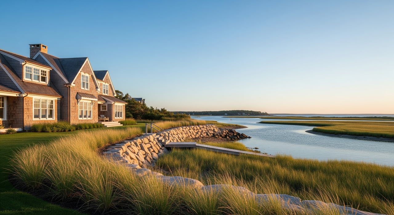
Docks, piers, and seawalls
Shoreline structures are closely regulated. Small private docks are often possible with town and state permits. New seawalls or bulkheads face tighter scrutiny because of erosion and habitat impacts. Replacing or expanding in‑water or tidal structures can require multiple approvals and professional plans. Distinguish routine maintenance of an existing, permitted structure from new construction.
Septic systems and soils
Wastewater systems must meet siting and setback standards from the high‑water line and any wetlands. If a system fails, replacement options can be limited by setbacks and soil conditions. Some lots need advanced treatment systems or creative siting to comply. Obtain septic design and installation records and consider a soils evaluation by a licensed site evaluator.
Nonconforming and grandfathered status
Many coastal homes predate current standards. A structure that is closer to the water than current rules allow may be legally nonconforming. Maintenance is typically allowed, while enlargements and significant reconstruction can be restricted or may trigger compliance with current rules. Always verify permit history and clarify what expansions, if any, are possible.
Erosion control and stormwater
Projects that create or expand impervious areas often require erosion and sediment controls and stormwater management. Expect to use best management practices such as silt fencing, stabilized construction entrances, and designed infiltration or dispersion areas. These requirements add design steps and cost, but they protect the shoreline and help secure permits.
Floodplain and coastal zone interplay
If the parcel is in a FEMA flood zone, local floodplain standards will apply to new construction and substantial improvements. Elevation, foundation type, and flood‑resistant construction can affect design and budget. Floodplain rules work alongside shoreland zoning, so factor both into feasibility.
Permits, variances, and risk
Most vegetation clearing in the shoreland buffer, new construction, expansions, and docks require a local shoreland or building permit from the Wells Code Enforcement Officer. Work in or adjacent to tidal waters or wetlands may also need state DEP permits and, in some cases, Army Corps authorization. Start with the town and ask for written guidance on permit pathways.
If an existing structure does not meet today’s setbacks, you can usually maintain it within defined limits. Rebuilding after damage, enlarging a nonconforming section, or relocating a structure are often subject to strict rules. Get the property’s permit file and confirm whether past work was properly approved. Unpermitted alterations can result in fines, restoration orders, and transaction delays.
When a proposal cannot meet a standard, you may apply for a variance through the local Board of Appeals. Variances require showing hardship under state and local criteria, and they are granted case by case. Appeals of decisions are possible but can be time‑consuming and costly. Plan timelines accordingly and avoid relying on a variance to make a purchase pencil out.
Buyer checklist for Wells shorefront
- Identify the shoreland zone and district for the parcel; get the zoning map and confirm boundaries on a survey.
- Request the complete permit history from the Town of Wells, including building, shoreland, septic, and any variances or enforcement actions.
- Verify setbacks for principal and accessory structures, decks, and septic components.
- Confirm lot coverage and impervious surface limits applicable within the shoreland zone.
- Review vegetation and buffer rules, including standards for view corridors and selective cutting.
- Assess any existing dock, bulkhead, or seawall for permitting status and feasibility of repair or replacement.
- Check FEMA flood zone designations and elevation requirements for the property.
- Order a survey locating the normal high‑water line or wetland edge, property lines, and topography.
- Obtain septic system records; if needed, schedule a soils evaluation with a licensed site evaluator.
- Meet with the Wells Code Enforcement Office or Planning Department early to review your plans and confirm required permits.
- Budget for professional studies and potential multi‑agency approvals, including engineering or environmental consulting.
Who to contact
- Town of Wells Code Enforcement Office and Planning Department for local permits and ordinance questions.
- Town of Wells Land Use Office for the Shoreland Zoning Ordinance and zoning maps.
- Maine Department of Environmental Protection for shoreland zoning program guidance and state minimum standards.
- U.S. Army Corps of Engineers for work in tidal or navigable waters.
- FEMA for Flood Insurance Rate Maps and floodplain requirements.
- Licensed local professionals: surveyor, soil/site evaluator, coastal engineer, wetland scientist, shoreland‑savvy contractor, and an attorney if permit issues arise.
Work with a shoreland‑savvy advisor
Buying along the Wells coastline is a lifestyle move and a technical project. You will benefit from an advisor who speaks both languages. With dual licensure in Maine and New Hampshire and hands‑on development experience, Brooke helps you evaluate setbacks, coverage, buffers, docks, and septic constraints before you commit. You get clear guidance, realistic timelines, and a plan to move from offer to permit to closing.
If you are weighing a waterfront purchase or planning a renovation, connect with Brooke Peterson for local insight and next steps. Request your instant home valuation, review your goals, and map your permitting path.
FAQs
How far from the water can I build in Wells?
- Setback distances vary by shoreland district and structure type, so confirm the exact requirement for your lot with the Town of Wells before designing a project.
Can I clear trees to open a view on a Wells waterfront lot?
- Selective trimming for views is often allowed under specific rules, but buffer areas must be maintained; get town guidance before removing vegetation.
What happens if a Wells home or dock is closer to the water than current rules allow?
- It may be a legal nonconforming structure that you can maintain, but expansions or major rebuilds are restricted and may trigger current standards.
Can I replace or expand a septic system inside the shoreland zone?
- Yes, if siting and soils support it, but systems must meet separation distances and design standards; a licensed site evaluator can confirm feasibility.
What permits are needed for a new private dock in Wells?
- Expect a local permit and likely a state DEP review; work in tidal or navigable waters may also require Army Corps authorization.
How do FEMA flood zones affect building on Wells waterfront property?
- Floodplain standards may require elevation, specific foundation types, and flood‑resistant design in addition to shoreland zoning rules.
What if I discover unpermitted work during a Wells waterfront purchase?
- The town can require corrections, fines, or restoration; unresolved violations can delay financing and closing, so address them before proceeding.